
Coopers Plains Precinct Petition Strongly Supported
Last Wednesday a meeting of local residents approved a petition to Brisbane City Council requesting three alterations to our shopping precinct on the neighbourhood strip of Orange Grove Road between Musgrave Road and Boundary Road:
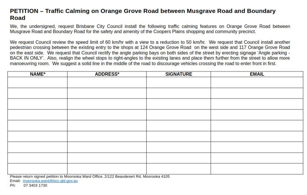
The petition was signed by many people in the immediate area after considerable time canvassing the issues. Local Cr Steve Griffiths will submit the petition by Tuesday 3rd to meet a deadline for Council’s first committee meetings on the fourth of February.
The three main requests in the petition are congruent with the nature of Orange Grove Road. We are calling them ‘traffic calming’ measures, but BCC’s terminology is different:
Local Area Traffic Management (LATM), also known as traffic calming, involves installing devices such as speed platforms, roundabouts, traffic islands and kerb build-outs
BCC Road Safety programs
Therefore, our requests are not ‘traffic calming’ as such. Our requests are allowable on Orange Grove Road and seek to enhance safety of both pedestrian and traffic movement.
Road Hierarchy
To understand what is allowable, one needs to understand Council’s Road Hierarchy. This hierarchy classifies roads according to expected traffic volume and capacity. At the top is Motorway and at the bottom is Neighbourhood Road.
- Motorway
- Arterial
- Suburban
- District
- Neighbourhood
It is necessary to be familiar with the classification of roads in our suburbs to understand Council’s intentions for traffic flow though it.

Orange Grove Road is classified as Arterial. Examples of Arterial roads are Logan Road (Mt Gravatt) and Kingsford Smith Drive (Hamilton). Do they seem similar to Orange Grove Road in Coopers Plains? Not really. How this came to be is explained in the way Orange Grove Road evolved over time.

Characteristics of Arterial roads include:
(See hardcopy “Roads & Traffic FactSheet” available at local Ward offices and online at the BCC’s website.)
- enable traffic flow through Brisbane
- no direct property access where possible
- connects major centres of regional importance (hospitals, universities, recreation, entertainment and conference and large industrial areas)
- signed speed limits of up to 80 km/h
- parking may be restricted during peak traffic times
- dedicated cycle facilities
- generally suitable for all vehicle types
For comparison, Boundary Road from the intersection with Orange Grove Road to the end of Miles Platting Road at Eight Mile Plains (including McCollough Street and Padstow Road) is classified as Suburban. This is already a four lane road all the way through. When the overpass at the railway crossing is complete, it could be reclassified as Arterial.
A Suburban road is described as;
- no direct property access where possible
- parking may be restricted during peak traffic times
- signed speed limits of up to 80 km/h
- dedicated cycle facilities
- suitable for all types of vehicles
The below roads are examples:
- Webster Road, Stafford
- Zillmere Road, Zillmere
- McCullough Street, Sunnybank.
Troughton Road is classified as a District road:
District roads (major roads) connect neighbourhood centres and catchments of about 1000 households in the outer suburbs and 3000 households in the inner suburbs (within 5 km). District roads help move people and goods within and through suburbs. Characteristics include:
- enable traffic flow through districts and suburbs
- no direct property access where possible
- connects neighbourhood centres (schools, recreation and open space and small industrial areas)
- signed speed limits of up to 60 km/h
- parking may be restricted during peak traffic times
- generally suitable for all types of vehicles.
The below roads are examples:
- Earnshaw Road, Northgate
- Park Road, Milton
- Ham Road, Mansfield
Functionally, Orange Grove Road in Coopers Plains matches the description of a District Road in the road hierarchy.
In order to achieve the overall outcome I have called for earlier, it may be necessary to request a change of classification to our neighbourhood stretch of Orange Grove Road. To assist the smooth flow of traffic around it, the classification of intersecting roads may need be taken into account. For example, if Orange Grove Road (between Musgrave and Boundary Rds) becomes a Suburban road, Musgrave Road (between Orange Grove and Troughton Rds) could become a District road to divert traffic. This would see a modest dispersal of traffic on to Musgrave Road and Troughton Road. Another diversion method I have called for before is to connect the western stretch of Musgrave Road to Beaudesert Road. This would require a small bridge over the suburban rail line.
The Overpass
The Boundary Road overpass at the level crossing is slated to begin construction mid 2025, rumour has it. The kind of overpass we get will decide the impact on our neighbourhood section of Orange Grove Road.
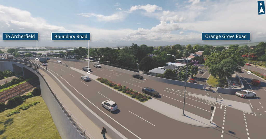
Having spoken to many people associated with the area affected by the overpass, it has become apparent to me that TMR may have been given the impression that their Option 2 (the bigger option) – was favoured by the community. It is also become apparent to me after talking to many people up and down the road, that some of those who favoured Option 2 (the elevated intersection) are having second thoughts. It seems that the combination of frustration over such a long wait for the overpass (60+ years) and having become accustomed (or resigned) to unrelenting population growth, bigger seemed better. It is only now occurring to some that less may be more when considering the extra traffic Option 2 will direct on to Orange Grove Road. We have all become accustomed to providing for excessive and unnecessary demand. More and more people are realizing how that induces demand.
The merits of Option 1 (Orange Grove Road cuts under the overpass and connects to Breton Street) may not yet have been fully realized by both the local community and those wanting to pass through on Boundary Road. More time is needed for the public to consider the local traffic flow around the Boundary Road end of Orange Grove Road. More canvassing of opinions of those in that area is needed.
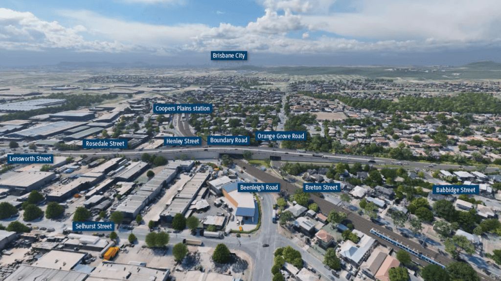
It is not yet known to me whether TMR will build their 1st or 2nd Overpass Option. However, for the sake of our neighbourhood, the next campaign will involve a consideration of local road classification and the best overpass option for those of us living and working in the area and the reasonable expectations of those needing to pass through it or around it.
Letter to the Minister of TMR
I have written to the Minister for Transport and Main Roads, Brent Mickelberg MP, the Premier and Deputy Premier. I encourage every concerned resident to do the same. Also, feel free to leave comments below.
The next campaign will begin early in 2025 This will involve canvassing residents, businesses and organizations around the Boundary Road end of Orange Grove Road. Stay tuned.

Leave a comment