
The Territory – An Afterthought
The Commonwealth’s current state and territorial borders evolved from decisions made by colonial administrators in Sydney, London and to some extent the fledgling settlements that were being established across the continent. They drew borders on a map that divvied up the continent between major cities that would act as centres of administration. The borders were more or less equidistant from these centres. This was part of the British strategy of claiming the whole continent before any other European power could. Settling the tropics lagged behind as Australia’s predominantly European population naturally preferred the cooler south.
COLONIZING THE TROPICS
Darwin was the most challenging settlement to establish because of its climate and remoteness from the other major settlements.
The Commonwealth’s borders were subject to considerable change up until the 1930s after the Imperial Conferences when Australia’s federal government gained more power over internal affairs. Power devolved from London and border changes slowed down as the process involved more local consultation. For example, a colony of North Australia covering most of present day Queensland and the Northern Territory existed for all of two years in 1846-7.
Formerly enacted by Letters Patent and signed into existence by Queen Victoria, North Australia was a failed experiment at settling the area around present day Gladstone (then known as Port Curtis). At the time, there were numerous ex-convicts roaming Tasmania with little to do, so colonial authorities decided that relocating them and giving them some land and support would help develop the north.


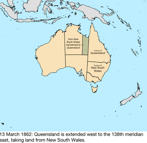
The colony of Queensland separated from NSW in 1859 after years of agitation by the northern colonists who were frustrated with the Sydney government. The ill-defined western border on the 141st meridian changed in March, 1862, when Queensland absorbed part of what is now the Northern Territory up to the 138th meridian. The reasons given were that the 138th meridian was a more barren tract of land and it would bring Burketown, the nearby ‘Plains of Promise’ and its harbour on the Gulf of Carpentaria within Queensland’s jurisdiction. This has never really been utilized by Queensland.
Borders that divide populated regions inevitably give rise to discontent, as was the case in the Tweed Valley:
While the Letters Patent of 6 June 1859 defined the Queensland – New South Wales border west of Coolangatta as latitude 29° S, people living in the Northern Rivers and New England Tableland areas still held the hope they would be included within Queensland as suggested in Lang’s proposal. His proposal saw the border being at latitude 30° S. This hope was reflected in published maps of the time which show the area between latitudes 29° S and 30° S as ‘Debateable Territory’ in the map.
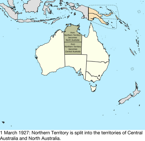
As late as 1927, the Northern Territory was divided into two territories – Northern Australia and Central Australia – only to be remerged 4 years later. This was the last major alteration to the borders on the mainland.

State/Territorial borders in colonial Australia
In as much as past state border delineations have been based on a principle of proximity to their centre of administration, Queensland and Western Australia are exceptions.
QUEENSLAND IS A TAD TOO BIG
In the late 1890s, Queensland’s size caused an internal dispute about whether it should be divided into two or three separate provinces with its own federal structure. This dispute prevented it from sending representatives to the crucial 1897 – 1898 Constitutional Convention Debates. It was argued that geographically, Queensland was too big. The climate, lifestyle and needs of the people in the south near Brisbane were quite different from those of the people in Cairns or Cape York. These sentiments have continued to the present day. I have suggested that a solution to this is the creation of a great north Australian state I call Capricornia.
A DISCONNECTED WEST
Western Australia is of course geographically even larger, with fewer people. Also, Perth is far more remote from the other cities – in fact it’s the most isolated city in the world. It was the most reluctant to federate and only joined at the last minute. A few decades later, 60% of West Australians voted to secede but this was rejected by the Commonwealth parliament. World War 2 intervened and saw the secessionist cause recede into the background.
A lot has changed since these borders fell into their current position. We know much more about the land, its people and resources. Cities like Mt Isa have grown up around mining while others like Cairns, Katherine and Kununurra are tourist, transport and agricultural centres. Many Aboriginal Land Councils have become well established on Native Title land across at least 20% of the tropical north and arid centre. All these areas could combine to form a new northern state, which I call Capricornia (LINK).

Leave a comment